|
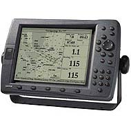
Details:The GPSMAP 2010 is worthy of the high seas. The GPSMAP 2010 is a full-featured chartplotter that boasts a 10-inch screen. You'll be amazed at the exceptional resolution and extremely fast redraw and response time. The rugged display is waterproof and submersible up to 1 meter. Designed for use above deck or at the navstation, these chartplotters are waterproof and easy to read, even in sunlight. Built-in worldwide basemap showing cities, interstates, coastline detail and US tide stations. For greater detail the GPSMAP 2010 is compatible with Garmin's exclusive BlueChart cartography. The 2010 has a dual card slot increased coverage area on line at all times. The external GPS sensor is capable of processing both WAAS and RTCM Differential correction data (DGPS Sensor not included) which deliver position accuracy to within three meters (on average). The 2010 is packed full of memory with 3000 waypoints with name and graphic symbols and 50 routes which hold 50 waypoints per route. Audible alarms for anchor drag, arrival, off-course, proximity waypoint and clock. Large number options for easy viewing. Trip computer provides odometer, stopped time, moving average, overall average, total time and max speed. Position formats include Lat/Lon, UTM, Loran TDs, Maidenhead, MGRS and user grid. 5000 point automatic track log which lets you retrace your path in both directions. Built-in to the GPSMAP 2010 are celestial tables for sun and moon calculation, great for the serious fisherman. With WAAS-enabled technology, sunlight readable, full featured, user friendly, GPS ChartPlotter and a large viewing area you can't ask for anything else. Dimensions; 8.75''H x 13.0''W x 2.75''D.
|